📖 Read more: Stonehenge: The Mysterious Stone Circle
🛰️ When AI Archaeology Meets Ancient Mysteries
The breakthrough came from combining high-resolution satellite imagery and machine learning algorithms. Dr. Michal Birkenfeld's team at Ben-Gurion University of the Negev processed two decades of satellite data, training AI to spot patterns that human eyes had missed. "Rujm el-Hiri — once considered an almost unique monument — is revealed as the most impressive example of a regional phenomenon," explains Birkenfeld, the study's lead researcher. But how do you find stone circles that have evaded archaeologists for generations? The answer lies in patience and processing power. Using archives from multiple satellite platforms — including Google Earth Pro and CNES/Airbus imagery — the team analyzed data spanning 2004 to 2024. AI algorithms filtered out interference from shadows and seasonal vegetation, revealing geometric patterns invisible to traditional ground surveys.📖 Read more: 1.5-Million-Year-Old Stone Tools Found in Indonesia
🏛️ The "Golan Stonehenge" Gets Company
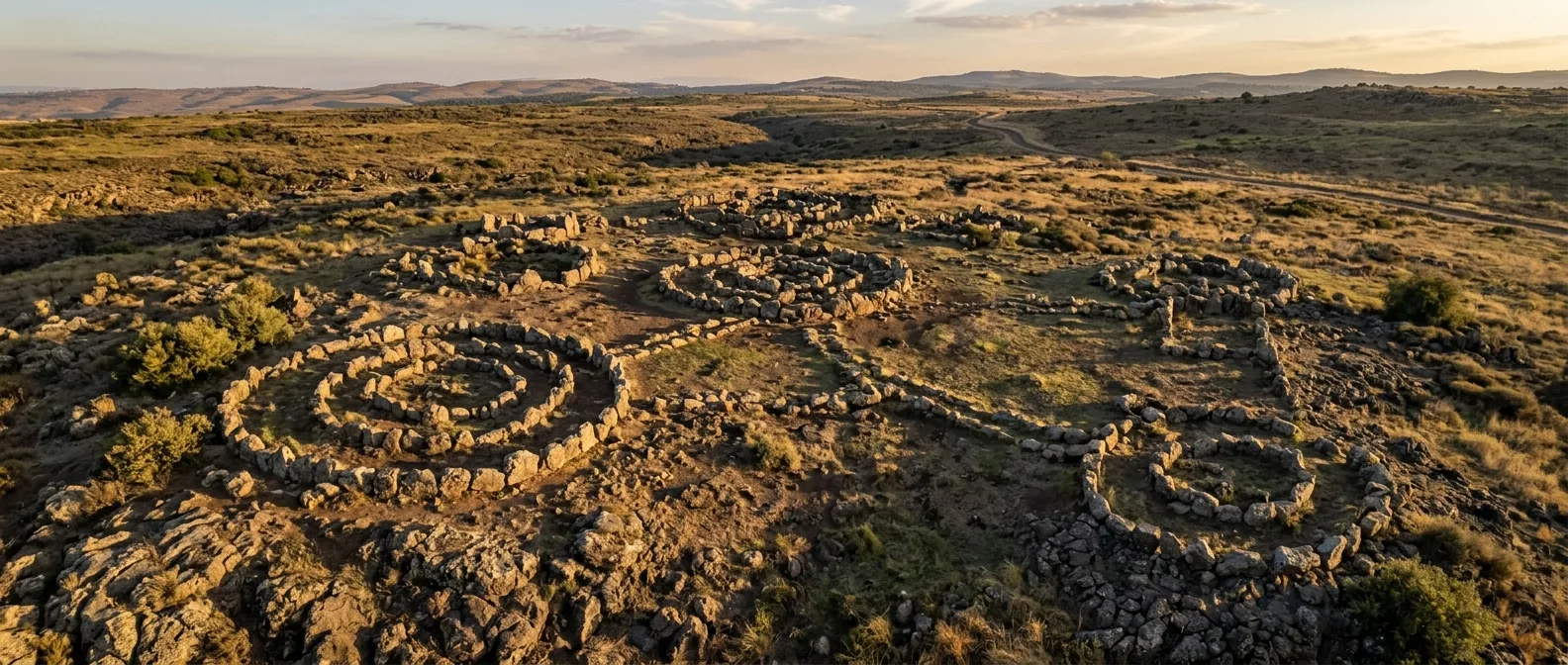
Rujm el-Hiri remains impressive: five concentric stone circles with an outer diameter of 152 meters, a central cairn rising five meters high, and over 40,000 tons of basalt stones. Discovered in 1968 through aerial photography after Israel captured the Golan Heights from Syria, it seemed like a one-off wonder. Not anymore.Architectural DNA Spanning Millennia
The newly discovered structures share striking similarities: circular walls built from local basalt stones, internal divisions (often radial or rectangular), and strategic placement near seasonal water sources. This "construction blueprint" remained consistent from 3500 BCE — raising questions about how prehistoric communities maintained such architectural traditions. "If this isn't a unique structure, I find more support for the idea that it was a gathering place," Birkenfeld observes. But why did so many communities choose the same megalithic "recipe"? The consistency suggests something deeper than coincidence. These weren't isolated experiments in stone architecture — they represent a shared cultural language that spread across the southern Levant.⚡ Astronomical Theories Under Fire
For decades, Rujm el-Hiri has been linked to astronomical observations. Openings in the stone walls appeared to align with the sun during summer and winter solstices. But the new research demolishes this theory with... geophysics.New Theories for Old Mysteries
The discovery of dozens of similar structures shifts the narrative from "unique monument" to "widespread tradition." If these monuments weren't astronomical observatories, what were they?"It's an enigmatic monument. We have fragmentary information but not the complete picture."
— Uri Berger, Israel Antiquities Authority
📖 Read more: 10 Hidden Secrets of the Athenian Acropolis You Never Knew
🔬 Methodological Revolution in Archaeology
The research published in PLOS One includes authors from three different institutions and countries: Michal Birkenfeld (Ben-Gurion), Olga Khabarova (Luxembourg), Lev V. Eppelbaum (Tel Aviv/Azerbaijan), and Uri Berger (BGU Ph.D. student/IAA researcher). The methodological advance lies in integrating high-resolution satellite imagery, AI, geophysical modeling, and spatial analysis into a single archaeological toolkit.Satellite Technology
Archives from 2004-2024, multiple platforms
Artificial Intelligence
Reduced interference from shadows and vegetation
Spatial Analysis
Pattern detection and correlation mapping
📖 Read more: 160,000 Stone Tools Found in China Break Records
🌍 A Lost Cultural Geography
The placement of these new structures isn't random. Most sit on gentle slopes or elevated plateau points, always near seasonal water sources. They often coexist with dolmens, tumuli, and networks of agricultural walls — elements pointing to a complex cultural landscape. Intriguingly, similar monuments have been spotted as far as Galilee and Lebanon. Did a unified "megalithic tradition" once span the entire southern Levant?From Agropastoralists to Digital Archaeologists
Analysis suggests these structures served agropastoral communities during the Chalcolithic and Early Bronze Age (roughly 3500-2000 BCE). While their chronological use remains unclear, the circles appear to have served multiple purposes:- Ritual gathering spaces: Community events and ceremonies
- Territorial markers: Boundaries of control or usage areas
- Seasonal centers: Meeting points for nomadic communities
📖 Read more: 5,000-Year-Old Rock Art Reveals Saudi Arabia's Hidden Past
📊 What This Discovery Changes
The 2026 research isn't just "another archaeological find." It represents a shift in how we understand prehistoric monuments — from isolated "anomalies" to components of complex social networks.Technology as Archaeological Tool
The method's success opens new horizons for archaeology. Regions that remain inaccessible due to geopolitical constraints — like parts of the Golan — can now be "surveyed" remotely. "Traditional archaeological methods remain essential," Birkenfeld emphasizes. "But this landscape-based approach allows us to reach a more complete understanding of the monuments." The question remains: how many other "unique" monuments will prove... not so unique?🎯 Frequently Asked Questions
When was Rujm el-Hiri built?
Construction began around 3500 BCE (Neolithic period), roughly contemporary with Stonehenge. However, parts were added over the following two millennia, making it the work of an entire "cultural period."
How did AI help with the discovery?
Machine learning algorithms processed satellite images from different seasons and lighting conditions, reducing interference from shadows and vegetation. This revealed structures invisible to traditional ground surveys.
Why aren't astronomical observatories viable anymore?
Geophysical studies show the region has undergone tectonic rotation of 8-15 millimeters per year. Over 5,000 years, this means displacement of several meters — enough to "destroy" astronomical alignments.
The discovery of dozens of "hidden" megalithic circles in the Golan Heights reminds us that the past still holds surprises — even in places we think we "know." When technology meets archaeology, it can reveal not just new monuments, but entire networks of human activity lost to time. The question that remains: in how many other regions of the planet do similar discoveries await?Sources: