Picture this: you're 2,000 miles from the nearest land, surrounded by nothing but endless blue water. No GPS. No compass. No charts. Just you, your canoe, and the night sky. For Polynesian navigators, this wasn't a nightmare scenario — it was Tuesday. Using stars as their roadmap and the ocean as their textbook, they colonized thousands of islands across one-third of Earth's surface.
📖 Read more: Persians: The Empire That Ruled the World
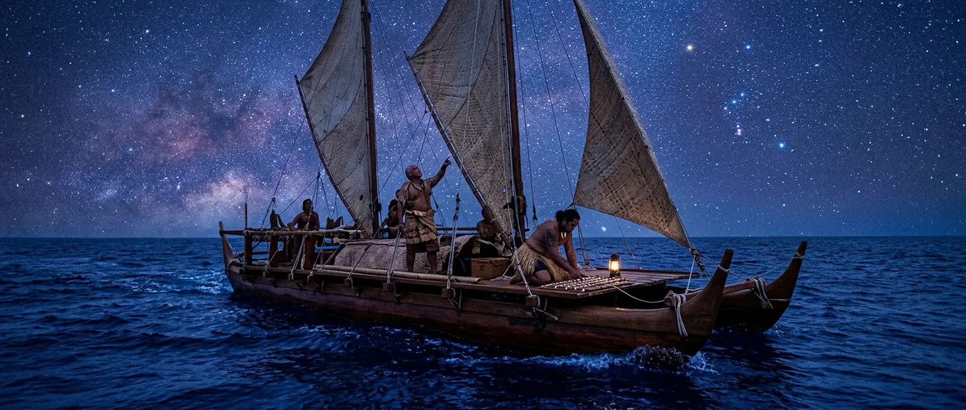
🌟 The Art of Stellar Navigation
Polynesian navigators developed a navigation system that could pinpoint destinations across thousands of miles of open ocean. Without written charts or metal instruments, they relied entirely on deep knowledge of the natural world. Stars weren't just pretty lights in the sky — they were highways, landmarks, and GPS coordinates all rolled into one.
Every navigator spent years apprenticed to master wayfinders. They memorized hundreds of stars and constellations, tracking their rise and set positions across different seasons. This knowledge passed down orally through generations, often encoded in songs and stories that made the complex information easier to remember.
The system worked with stunning accuracy. Polynesian navigators could sail thousands of miles with minimal error, traveling from Hawaii to Tahiti, from New Zealand to Easter Island, crossing vast stretches of open ocean without losing their way. They created reliable sailing routes connecting islands from Hawaii to Easter Island.
🗺️ The Star Compass System
Polynesian navigators created a mental map of the sky they called the "star compass." This compass divided the horizon into 32 points, each corresponding to where specific stars rose or set. Think of it as invisible highways carved across the heavens.
Every island had its own "star path" — a sequence of stars to follow to reach that destination. To sail from Tahiti to Hawaii, for example, you'd follow Arcturus as it rose. As one star set, the navigator would turn to the next in the sequence, creating a continuous chain of celestial guidance.
Even more sophisticated: Navigators didn't just watch stars. They tracked the sun's position during the day, using shadows and angles to maintain course. Even when clouds covered the sky, they could locate the sun by reading the brightness patterns in the cloud cover.
🌊 Reading the Ocean
Polynesian navigation wasn't just about stars. These seafarers learned to "read" the ocean itself with breathtaking precision. They watched waves, currents, even water color to determine their position and distance from land.
Ocean swells create specific patterns when they encounter islands. Experienced navigators could feel these changes in their boat's motion, even when they were dozens of miles from shore. They could detect an island's presence long before it became visible on the horizon.
Even more impressive were their "signs of land." Birds flying in specific directions at evening, clouds forming over invisible islands, even the reflection of lagoon light on the undersides of clouds — all these became signposts guiding navigators to their destinations.
Wave Reading
Navigators recognized different wave types: large ocean swells, waves reflected off islands, and refracted waves around land masses. Each type provided information about distance and direction to shore.
Bird Flight
Specific seabird species flew known distances from land. By watching their flight directions in morning and evening, navigators could pinpoint nearby islands.
Cloud Formations
Islands create characteristic cloud patterns. Even invisible islands could be detected by clouds forming above them or by the greenish reflection of lagoons on cloud undersides.
⛵ The Vessels of Great Journeys
Polynesian double-hulled canoes were marvels of engineering. Built without metal tools, using only wood, plant fibers, and natural resins, these vessels could travel thousands of miles across open ocean. Their twin-hull design provided stability, while triangular sails allowed fast, flexible navigation.
The largest vessels could carry up to 80 people, along with food, water, animals, and plants for establishing new colonies. They were designed to handle the Pacific's harsh conditions, with flexible joints that absorbed wave energy instead of breaking.
Building such a vessel required months of community effort. Every piece of wood was carefully selected, every lashing tied with specific techniques. Shipbuilders followed traditional methods perfected through centuries of experience.
💡 Did You Know?
In 1976, the Polynesian Voyaging Society built the Hōkūleʻa, a traditional double-hulled canoe, and successfully completed the Hawaii-Tahiti voyage using only traditional navigation methods. The 2,500-mile journey took 34 days and proved the effectiveness of ancient techniques.
📖 Read more: Roman Coins: Ancient Propaganda Cast in Metal
🏝️ Conquering the Pacific
The Polynesian expansion across the Pacific ranks among humanity's greatest exploration achievements. Starting from Southeast Asia around 3,000 years ago, they colonized thousands of islands across an area covering one-third of Earth's surface.
Each new voyage was carefully planned. Explorers didn't set out randomly — they watched wind patterns, bird flights, even currents carrying driftwood and seeds from unknown lands. When they spotted signs of new islands, they organized exploration expeditions.
Their success wasn't just about sailing skills. Polynesians were also excellent farmers and fishers, capable of creating sustainable communities on remote islands. They carried plants like taro, breadfruit, and coconut, along with animals like pigs, chickens, and dogs.
📚 Preserving Knowledge
In a culture without writing, preserving and transmitting complex navigation knowledge was challenging. Polynesians developed clever ways to ensure this knowledge passed from generation to generation.
Songs and chants contained encoded information about star paths and sailing techniques. Apprentice navigators spent years memorizing these songs, which functioned as living charts and navigation manuals.
On some islands, like the Marshall Islands, navigators created "stick charts" — frameworks of thin sticks representing wave patterns around islands. These weren't for use at sea, but teaching tools that helped students understand ocean behavior.
🔱 Navigation System Comparison
🌅 Reviving a Lost Art
With European arrival and modern navigation methods, traditional techniques began disappearing. For decades, it seemed this ancient knowledge would vanish forever. Fortunately, some elderly navigators kept the tradition alive.
The founding of the Polynesian Voyaging Society in 1973 marked the beginning of a renaissance. Young Polynesians began relearning their ancestors' techniques. The Hōkūleʻa and other traditional vessels have completed dozens of voyages, proving ancient methods still work.
Today, navigation schools across Polynesia teach traditional techniques to new generations. This isn't just about preserving the past — it's recognizing that this knowledge has value in the modern world. In an age of climate change and environmental challenges, the deep natural understanding of Polynesian navigators offers valuable lessons.
🔬 Scientific Validation
Modern science has confirmed the accuracy of Polynesian navigation methods. Studies show traditional navigators could determine their position with accuracy comparable to early European navigation systems.
Particularly impressive is their ability to detect land from great distances. Research has confirmed that the wave patterns navigators observed do indeed change predictably near islands. Even their observation of phosphorescent algae in water, used to spot currents at night, has scientific basis.
Studying Polynesian techniques has enriched our understanding of human spatial abilities. Polynesian navigators could simultaneously track star positions, wave patterns, bird behavior, and cloud formations to determine their location within miles.