📖 Read more: Solar Drones: Endless Flight Powered by the Sun
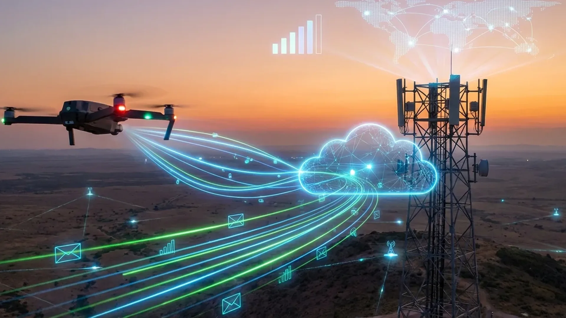
📡 What Are BVLOS Flights?
The term BVLOS (Beyond Visual Line of Sight) refers to unmanned aircraft flights conducted beyond the operator's visual range. Unlike VLOS flights — where the pilot must maintain unaided visual contact with the drone — BVLOS operations allow drones to fly tens or even hundreds of kilometers away, relying entirely on telecommunications links for control and data transmission.
📖 Read more: Underwater Drones: Exploring the Deep
According to the UTM (Unmanned aircraft system Traffic Management) program developed by the FAA and NASA, BVLOS flights take place at altitudes below 400 feet (approximately 120 meters) AGL (Above Ground Level) and form the foundation for the future of autonomous drone navigation in dense urban environments.
📶 Why 5G Is a Game-Changer for BVLOS Drones
While 4G/LTE networks have been used experimentally for remote drone piloting, they face serious limitations in latency, bandwidth, and reliability. 5G technology — which first launched commercially in April 2019 in South Korea — brings three critical advantages: ultra-low latency, massive bandwidth, and the ability to connect millions of devices simultaneously.
The three pillars of 5G for drones
URLLC — Ultra-Reliable Low Latency
Ultra-Reliable Low-Latency Communications (URLLC) targets latency as low as 1ms, critical for real-time drone control. In practice, current 5G networks achieve 8-12ms over the air — a massive improvement over 4G's typical 30-50ms.
eMBB — Enhanced Mobile Broadband
Enhanced Mobile Broadband delivers speeds of 5-900 Mbit/s on the sub-6GHz band (FR1) and multi-Gbit on mmWave (24-71GHz). This means live 4K video streaming from the drone with zero perceptible lag.
mMTC — Massive Machine Connectivity
Massive Machine-Type Communications allows millions of IoT devices — including drones, sensors, and base stations — to connect simultaneously without congestion or dropped signals.
🔬 5G Technical Specifications for Drone Operations
Understanding the technical characteristics of 5G is essential to appreciate how this technology is transforming drone capabilities. Below is a detailed comparison table of the key specs relevant to BVLOS flights.
| Specification | 5G FR1 (Sub-6GHz) | 5G FR2 (mmWave) |
|---|---|---|
| Download Speed | 5-900 Mbit/s | Multi-Gbit/s |
| Theoretical Peak | Up to 4.5 Gbps | Up to 20 Gbps |
| Latency (Air) | 8-12ms | 4-8ms |
| URLLC Target | 1ms | |
| Upload Speed | Up to 500 Mbit/s | Up to 10 Gbps (peak) |
| Range | Long (kilometers) | Short (100-300m) |
| Best Drone Use Case | Long-range BVLOS | Dense urban, data-heavy |
Network Slicing: A dedicated network for drones
One of the most innovative 5G capabilities for BVLOS flights is Network Slicing. Using SDN (Software-Defined Networking) and NFV (Network Functions Virtualization) technologies, telecom providers can create virtual network “slices” dedicated exclusively to drone operations. Each slice guarantees specific latency, bandwidth, and reliability levels — regardless of traffic on the rest of the network.
For instance, a network slice for critical drone command & control can guarantee latency <5ms with 99.999% reliability, while a second slice for video streaming can provide guaranteed 50+ Mbit/s bandwidth — without the two interfering with each other in any way.
Did you know: Qualcomm has successfully demonstrated cellular-enabled drone deployments, proving that existing mobile network infrastructure can serve as a control backbone for autonomous drones without the need for specialized radio links.
🌍 UTM: The Drone Air Traffic Management System
For BVLOS flights to work at scale, connectivity alone isn't enough — a comprehensive air traffic management system specifically designed for drones is required. That system is UTM (Unmanned aircraft system Traffic Management).
UTM is being developed through a collaboration between the FAA (Federal Aviation Administration) and NASA in the United States, and by SESAR in Europe as U-space. The goal is to create an ecosystem for safe autonomous UAS flights at altitudes below 400 feet.
Airspace Organization
UTM defines flight zones, corridors, and no-fly zones in real time, taking into account weather conditions, traffic density, and permanent restrictions such as airports and military zones.
Collision Avoidance
Through real-time deconfliction, the system ensures no drone gets dangerously close to another aircraft — manned or unmanned. Remote ID functions as a “digital license plate” for every drone.
Flight Authorization
Every BVLOS flight requires real-time digital approval, with automatic verification of both the operator (certification) and the aircraft (technical airworthiness).
Dynamic Adaptation
In an emergency — such as an incoming air ambulance helicopter — UTM automatically reroutes all drones in the area within seconds, clearing the airspace instantly.
Operation Zenith: The first live UTM demonstration
On November 21, 2018, Operation Zenith took place at Manchester Airport — the world's first live UTM demonstration. It involved 13 organizations and proved that multiple drones can operate simultaneously in controlled airspace alongside commercial aviation, using automated coordination systems.
🇪🇺 Regulatory Framework: EU and Beyond
The European Union has categorized drone operations into three tiers, with BVLOS flights falling under the “Special Category,” which requires a specific permit from the national aviation authority.
Open Category
Flights within visual line of sight, up to 120m altitude, drones up to 25kg. Subcategories A1/A2/A3 with corresponding certifications. BVLOS is NOT permitted.
Special Category
Flights exceeding Open Category limitations — including BVLOS. Requires a risk assessment (SORA) and a permit from the authority. This is where 5G BVLOS flights belong.
Certified Category
High-risk operations: cargo or passenger transport. Requires a type certificate, an air operator certificate, and a pilot's license — similar to manned aviation.
U-space: Europe's UTM system
The EU developed the U-space system through the SESAR Joint Undertaking — a set of services for safe and efficient drone access to airspace. The U-space regulation became mandatory across all member states on January 26, 2023. In the United States, the FAA published the Advanced Air Mobility (AAM) Implementation Plan on July 18, 2023.
In the US: Under FAA Part 107, commercial drone operations require a Remote Pilot Certificate. BVLOS waivers can be obtained through the Part 107 waiver process, though approval is heavily scrutinized and typically granted for specific use cases with proven safety mitigations. Remote ID — mandated since 2021 — serves as a prerequisite for future large-scale BVLOS approvals.
🚀 Real-World 5G BVLOS Applications
The convergence of 5G and BVLOS unlocks applications that were impossible with traditional radio links. From urban package delivery to autonomous facility patrols, the potential is enormous.
Medical Supply Transport
5G-connected drones carry blood, medications, and lab samples to islands, mountain communities, and disaster-stricken areas. BVLOS capability means fully autonomous missions without requiring visual contact along the route.
Infrastructure Inspection
Power transmission lines, oil pipelines, railway tracks — kilometers of infrastructure inspected automatically by AI-powered drones streaming HD video in real time over 5G networks.
Precision Agriculture
Drones survey BVLOS stretches covering hundreds of acres, mapping moisture levels, detecting crop diseases, and applying targeted spraying — cutting fertilizer and pesticide costs by 30-50%.
Urban Drone Delivery
Companies like Amazon (Prime Air) and Google (Wing) are scaling their drone delivery services. 5G ensures uninterrupted command & control even in dense urban areas with tall buildings and signal-blocking structures.
⚡ 5G-Advanced (Release 18): The Next Generation
While 5G is already transforming the landscape, the evolution continues. 5G-Advanced (also known as 5.5G), based on 3GPP Release 18, introduces capabilities specifically designed for autonomous systems:
- AI/ML Network Management: Networks will use machine learning to automatically optimize coverage and capacity around drone corridors in real time
- NTN (Non-Terrestrial Networks): Drone connectivity via satellites and airborne platforms, eliminating coverage dead zones over oceans and remote areas
- Extended Reality (XR): Remote drone piloting through VR headsets with zero-lag immersion, as though sitting inside the cockpit
- Digital Twins: Real-time digital replicas of urban areas, continuously updated via drone data — for urban planning, traffic management, and hazard detection
- Positioning Enhancement: Sub-10cm positioning accuracy via 5G signals, reducing GPS dependence in urban canyons where satellite signals bounce and degrade
⚖️ 5G BVLOS vs Traditional Radio Links
5G BVLOS Advantages
- No specialized radio equipment required
- Leverages existing cell tower infrastructure
- Latency of 8-12ms (target 1ms URLLC)
- Multi-Gbit bandwidth for 4K video
- Dedicated network slicing for drones
- Automatic handover between cell towers
- Built-in Remote ID support
Challenges & Limitations
- Dependent on network coverage along the route
- Coverage gaps in rural/mountainous areas
- 5G module costs still relatively high
- 5G modem power consumption on the drone
- Regulatory hurdles (being addressed gradually)
- Network security: cyberattack risk vector
- mmWave only works at close range
📅 Timeline: The Evolution of 5G-BVLOS
First live UTM demonstration at Manchester Airport with 13 organizations. Multiple drones operated alongside commercial flights using automated coordination systems.
South Korea activates the first commercial 5G networks (April 3, 2019). Verizon follows in the US the same day. First pilot 5G drone projects begin worldwide.
The FAA publishes Remote ID regulations: every drone must broadcast a “digital license plate” with its location and the operator's position — a prerequisite for future large-scale BVLOS approvals.
January 26: Mandatory U-space regulation enforcement across the EU. July 18: FAA publishes the Advanced Air Mobility Implementation Plan. BVLOS gains an official legal framework on both sides of the Atlantic.
First commercial BVLOS drone delivery networks in Europe. Pilot 5G-connected drone corridors along highways and railway lines. Testing of urban drone taxi routes and medical supply chains.
💡 Practical Tips for Drone Operators
If you're a drone operator interested in BVLOS flights, here are practical tips based on the current regulatory framework:
- Certification: First obtain your A1/A3 and A2 certificates in the Open Category. Then familiarize yourself with the SORA (Specific Operations Risk Assessment) methodology required for Special Category flights
- Equipment: Choose a drone with a built-in 4G/5G modem (e.g., DJI Matrice 350 RTK with 4G dongle, or specialized BVLOS drones). Cost: €11,000-€18,400 (~$12,000-$20,000) for enterprise-class platforms
- Insurance: Third-party liability insurance is mandatory in the EU for drones over 250g. For BVLOS operations, extended coverage is required — consult specialized drone insurers
- Flight Planning: Every BVLOS flight requires a detailed plan: route, alternatives, emergency landing points, and a 5G coverage map along the entire flight path
- Remote ID: Make sure your drone supports Remote ID — it's already (or will soon be) mandatory in both the EU and US markets
🔮 The Future: Fully Autonomous Drone Networks
The ultimate vision isn't simply a single drone flying beyond the operator's sight — it's an entire network of autonomous drones operating as an invisible “service layer” above our cities. Imagine: tens of thousands of drones simultaneously, each on a different mission — delivery, security, mapping, firefighting — all coordinated automatically by AI-powered UTM networks over 5G.
According to industry experts, by 2030, the majority of commercial drone missions will be BVLOS — with no human pilot in the loop. 5G-Advanced and eventually 6G (expected around 2030) will deliver sub-millisecond latency, terabit speeds, and native AI integration, transforming the sky into a digital highway.