What Is Drone Mapping?
Drone mapping is the process of using unmanned aircraft equipped with cameras or sensors to capture aerial imagery and create detailed maps or 3D models of a given area. According to UAVCoach's 2026 guide, a drone flies a pre-planned path capturing overlapping photos with GPS metadata. These images are then uploaded into specialized software that uses photogrammetry or LiDAR processing to reconstruct the area in 2D or 3D.
The standard image overlap is 70% frontal and 60% lateral, ensuring every ground point is captured multiple times. In the “crawl-walk-run” framework of progress, drone mapping is now in full “run” mode — a massive range of industries rely on it daily.
Types of Drone Mapping Outputs
The data captured during a mapping flight gets processed into various types of digital deliverables depending on project requirements:
Orthomosaic Maps
High-resolution, georeferenced 2D images corrected for perspective and scale — ideal for distance and area measurements.
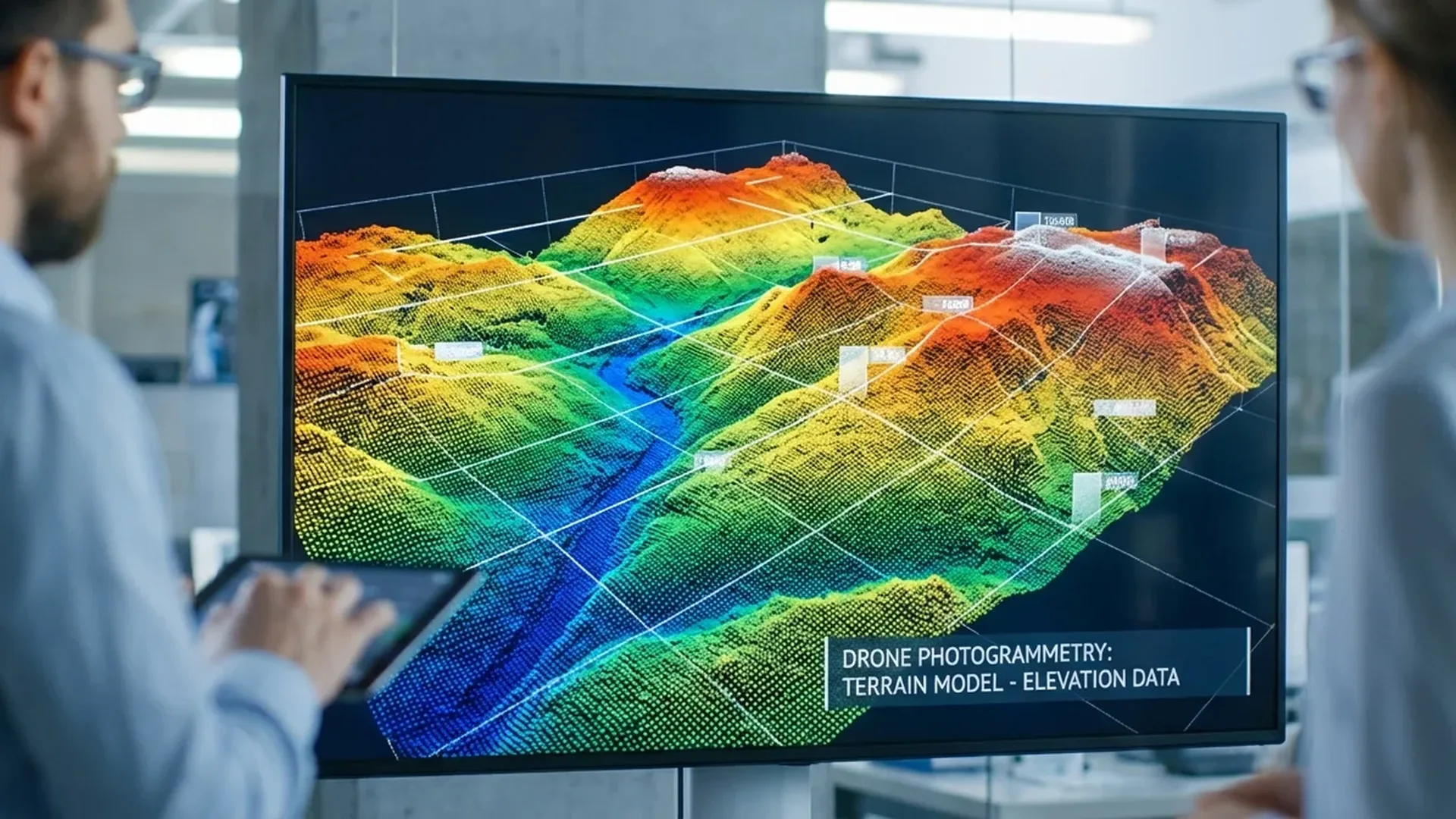
Digital Elevation Models (DEM)
3D surface elevation models used in construction planning, urban development, and flood modeling.
3D Models & Mesh
Three-dimensional reconstructions of buildings or terrain with textures, useful for inspection, planning, and presentations.
Point Clouds
Dense sets of 3D coordinates representing physical surfaces — the foundation for terrain models, volume calculations, and surveying.
Photogrammetry vs LiDAR
The two core technologies behind drone mapping are photogrammetry and LiDAR. Photogrammetry uses overlapping RGB photographs to generate maps and models — it's more affordable and ideal for most applications. LiDAR (Light Detection and Ranging) emits laser pulses that penetrate vegetation to reveal the actual ground surface beneath trees — critical for forestry and archaeology.
Photogrammetry
- Lower equipment cost
- Photorealistic textures & colors
- Ideal for orthomosaics & 3D models
- Works with standard RGB cameras
- Wide range of compatible drones
LiDAR
- Penetrates vegetation canopy
- Higher accuracy on bare terrain
- Works in low-light conditions
- Significantly more expensive (€11,000-€46,000+ / ~$12K-$50K+)
- Heavier payload → shorter flight time
Best Mapping Drones (2026)
According to UAVCoach's 2026 guide, the top mapping drones include both fixed-wing models for large-area coverage and multirotor options for flexibility. The right choice depends on the size of the area, required accuracy, and budget.
| Drone | Type | Flight Time | Coverage / Feature | Price (est.) |
|---|---|---|---|---|
| WingtraOne Gen II | Fixed-wing VTOL | Up to 59 min | 740 acres/flight, RTK/PPK | €18,400-€27,600 (~$20K-$30K) |
| DJI Matrice 350 RTK | Multirotor | Up to 55 min | 20 km range, Zenmuse L2/P1 | €11,040-€18,400 (~$12K-$20K) |
| senseFly eBee X | Fixed-wing | Up to 90 min | 1,200 acres/flight, PPK | €13,800-€23,000 (~$15K-$25K) |
| Freefly AstroMax | Multirotor | ~40 min | Modular payload, RGB/LiDAR | €16,560-€23,000 (~$18K-$25K) |
| DJI Mavic 3 Enterprise | Multirotor | Up to 45 min | RTK module, small areas | ~€4,600 (~$5,000) |
For smaller projects and getting started with mapping, the DJI Mavic 3 Enterprise (~€4,600 / ~$5,000) offers an excellent cost-to-performance ratio with its RTK module and 4/3 CMOS 20MP camera. For large-area coverage (mining, farmland, energy parks), fixed-wing models like the WingtraOne Gen II and eBee X dominate thanks to flight endurance of up to 59-90 minutes per mission.
GSD (Ground Sampling Distance): Ground resolution is measured in cm/px. Typical GSD for surveying work: 1-3 cm/px. For agricultural monitoring: 3-5 cm/px. Lower GSD = higher detail but longer flight time and processing.
Drone Mapping Software
Software selection is just as important as the drone itself. According to UAVCoach, the leading platforms for 2026 include:
DroneDeploy
All-in-one platform: flight planning, processing, and analytics. Ideal for teams needing cloud-based access and collaboration.
Pix4Dmapper
The gold standard for surveyors. Full RAW data control, RTK/PPK support, and survey-grade accuracy for professional deliverables.
DJI Terra
Optimized for DJI drones. 2D maps, 3D models, real-time outputs. The natural choice if you're already using DJI hardware.
Agisoft Metashape
For power users and academics. Deep customization, batch automation, and offline operation — ideal for sensitive data handling.
WebODM (Open Source)
Open-source solution for technical teams. Custom workflows, runs locally, zero licensing costs. Extensible and privacy-first.
Propeller
Specialized for construction and earthworks: automated cut/fill analysis, volume calculations, and easy client sharing.
Drone Mapping Applications by Industry
Drone mapping is deployed across a wide range of industries. According to UAVCoach, the top sectors leveraging this technology include:
🏗️ Construction: Pre-construction site surveys, weekly progress tracking, stockpile volume measurements, and cut-and-fill analysis for earthworks management.
🌾 Agriculture: Crop health monitoring via NDVI (Normalized Difference Vegetation Index), disease detection, irrigation planning, and precision farming at scale.
⛏️ Mining: Active pit and quarry mapping, stockpile volume change tracking, slope stability monitoring, and haul road inspection.
📐 Land Surveying: Topographic maps, cadastral surveys, base maps for subdivision layouts, and high-resolution orthoimagery for property development.
🌿 Environmental Monitoring: Wetland boundary tracking, shoreline erosion assessment, reforestation progress monitoring, and wildlife habitat surveys with minimal disturbance.
⚡ Utilities & Infrastructure: Power line and substation inspection, pipeline monitoring, and solar/wind farm surveys using aerial photography and thermal imaging.
Drone Mapping Workflow
A typical mapping mission follows 6 steps — from planning through delivery:
Mission Planning
Define project goals (accuracy, coverage, outputs), check airspace restrictions, set altitude & overlap (70/60%), select flight software (DroneDeploy, Pix4Dcapture, DJI Pilot).
Fly the Mission
Pre-flight checks (battery, GPS, sensors, weather). Autonomous flight on a programmed grid/lawnmower pattern with ground-based supervision.
Data Collection
High-resolution image capture with GPS geotagging. Best conditions: stable lighting, consistent altitude, uniform camera angle.
Data Processing
Transfer data to photogrammetry or LiDAR software. Incorporate GCPs (Ground Control Points) or RTK/PPK data for centimeter-level accuracy.
Analyze Results
Quality review, measurements, volume calculations, integration into GIS or CAD systems. Some clients need only raw data/maps, others want full analysis.
Delivery & Reporting
Deliver orthomosaics, 3D models, and point clouds via cloud platforms. Customized reports tailored to client specifications.
Costs & Pricing
Drone mapping costs depend primarily on equipment, software, and the type of work:
| Category | Price Range | Notes |
|---|---|---|
| Entry-level mapping drone | €1,840 - €4,600 (~$2K-$5K) | DJI Mavic 3 Enterprise, small areas |
| Professional mapping drone | €11,000 - €27,600 (~$12K-$30K) | Matrice 350, WingtraOne, eBee X |
| Software (annual) | €0 - €4,600 (~$0-$5K) | WebODM free / Pix4D ~€3,000+ (~$3,300+)/yr |
| Mapping service (per project) | €500 - €5,000+ (~$550-$5,500+) | Depends on area & deliverables |
| GCPs & accessories | €200 - €2,000 (~$220-$2,200) | GPS base station, targets, landing pad |
Drone Mapping in Greece
In Greece, drone mapping is gaining significant importance due to the country's challenging terrain — islands, mountainous regions, and rugged landscapes that make traditional surveying time-consuming and expensive. Key applications include:
- Cadastral Registry: Property surveys, boundary verification, and ownership declaration support
- Archaeology: 3D documentation of archaeological sites, monuments, and excavations
- Solar & Wind Energy: Site surveys for renewable energy park installations
- Urban Planning: City planning, illegal construction monitoring, and digital twins
- Environment: Forest area monitoring and post-wildfire damage assessment
Under the EASA 2019/947 regulation applied in Greece, mapping flights require at minimum an A1/A3 certification (free exam) or A2 (~€50-100 / ~$55-110) for flights closer to people. For specialized work with heavier drones, STS (Specific category) training may be needed (~€300-800 / ~$330-870). Registration with the Hellenic Civil Aviation Authority is free and mandatory.
"When done correctly, drone mapping can achieve centimeter-level accuracy — especially when using RTK/PPK systems and ground control points (GCPs). The final accuracy depends on your flight planning, equipment, and post-processing methods."
— UAVCoach, Guide to Drone Mapping (2026)Frequently Asked Questions
What accuracy can drone mapping achieve?
With RTK/PPK and GCPs, accuracy reaches 1-2 cm horizontal and 2-5 cm vertical. Without RTK, typical accuracy is 5-10 cm depending on the drone's GPS.
Do I need a surveyor's license for drone mapping?
In many jurisdictions, survey drawings used for legal or cadastral purposes must be signed by a licensed surveyor. However, you can provide raw data, orthomosaics, and 3D models as an external data provider working alongside licensed professionals.
What's the best mapping drone for beginners?
The DJI Mavic 3 Enterprise (~€4,600 / ~$5,000) offers an excellent cost-to-performance ratio with its RTK module, solid endurance (45 minutes), and DJI Terra compatibility.
How much does a drone mapping service cost?
Prices range from €500 (~$550) for small surveys (up to 2.5 acres) to €5,000+ (~$5,500+) for large areas with multiple deliverables (orthomosaic, DEM, 3D model, report).