Drones (UAVs) have become an essential tool in modern precision agriculture. From crop spraying and field mapping to disease detection with multispectral sensors, drone technology is transforming farming worldwide. The agricultural drone market is estimated at $2.63 billion in 2025 and is projected to reach $10.76 billion by 2030, growing at a compound annual growth rate of 32.6% (MarketsandMarkets, 2025).
Why Drones Are Changing Agriculture
Global agriculture faces unprecedented challenges: growing food demand, labor shortages, climate change, and the need for sustainable practices. Agricultural drones offer solutions to all these problems, while their prices have dropped dramatically in recent years.
According to MarketsandMarkets research (2025), the agricultural drone market is growing at 32.6% annually, primarily driven by demand for precision farming. Drones equipped with sensors, artificial intelligence, and analytics tools enable farmers to optimize their crops with an accuracy that was impossible just a few years ago.
Key Insight: Entry-level agricultural drones now cost €1,840-€3,680 (~$2,000-$4,000), down over 70% since 2016 (when they cost ~€13,340 / ~$14,500). Mid-range models (€7,360-€13,800 / ~$8,000-$15,000) include obstacle avoidance and automated mission planning — features previously found only in equipment costing over €18,400 (~$20,000).
5G technology and edge AI reduce response time below 20 milliseconds, allowing drones to transmit images and receive application maps during a single flight. Trials on US corn farms showed that onboard neural networks can classify crop stress with 94% accuracy, without requiring cloud data uploads.
Multi-rotor drones hold 62% of the market thanks to their hovering capability and spraying precision. However, hybrid VTOL (Vertical Take-Off and Landing) models are growing rapidly (+18.9% CAGR), as they combine vertical takeoff with fixed-wing flight endurance (90-180 minutes).
6 Key Agricultural Drone Applications
Agricultural drones are used across a wide range of applications. Crop monitoring holds 48% of the application market, while precision spraying is growing fastest at 18.4% annually (Mordor Intelligence, 2026).
Crop Monitoring
Multispectral sensors (NDVI) detect nutrient deficiencies, water stress, and growth problems before they become visible. RGB, Red Edge, NIR, and thermal cameras capture data across 4+ spectral bands.
Mapping & Surveying
Create orthophotos, 3D terrain models, and elevation maps. Ideal for irrigation planning, drainage design, and field boundary identification. Coverage up to 160 hectares (395 acres) per flight with fixed-wing drones.
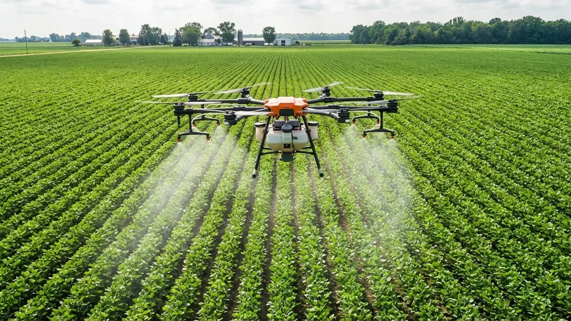
Precision Spraying
Targeted application of pesticides, fertilizers, and seeds. Modern spraying drones (e.g., DJI Agras T50) carry up to 40kg (88 lbs) of liquid payload, reducing chemical usage by 20-35%.
Irrigation Management
Thermal sensors detect water stress areas, irrigation system leaks, and uneven water distribution. Particularly useful in dry regions and Mediterranean climates like Greece.
Disease & Pest Detection
RGB and multispectral cameras detect diseases at an early stage. AI algorithms analyze the data and create infection hotspot maps, enabling targeted treatment instead of blanket spraying.
Livestock Monitoring
Locate animals across vast pastures, assess pasture conditions, and monitor herds. Particularly popular in Australia and South America, with growing adoption in Europe.
Best Agricultural Drones 2026
The market is dominated by DJI, which holds the leading position in agricultural drones, while competitors like XAG, Yamaha, Trimble, and Parrot offer specialized solutions. In July 2025, DJI announced the new Agras T100, T70P, and T25P series, featuring improved autonomy, payload capacity, and flight safety.
| Drone | Type | Payload | Flight Time | Price |
|---|---|---|---|---|
| DJI Agras T50 | Spraying / Seeding | 40kg liquid / 50kg solid | 15 min (loaded) | €13,800-€18,400 (~$15,000-$20,000) |
| DJI Agras T25 | Spraying / Seeding | 20kg liquid / 25kg solid | 18 min | €9,200-€13,800 (~$10,000-$15,000) |
| DJI Mavic 3 Multispectral | Mapping / NDVI | 0.9kg (sensors) | 43 min | ~€4,600 (~$5,000) |
| SenseFly eBee Ag | Mapping (fixed-wing) | RedEdge-MX sensors | 55 min | €9,200-€13,800 (~$10,000-$15,000) |
| XAG V40 | AI Spraying | 20L liquid | Autonomous AI | €4,600-€9,200 (~$5,000-$10,000) |
DJI Agras T50 — The King of Crop Spraying
The DJI Agras T50 is the world's leading agricultural spraying drone. Capable of carrying 40kg (88 lbs) of liquid spray or 50kg (110 lbs) of solid fertilizer/seeds, it efficiently covers large areas. It features dual radar, binocular vision, and RTK centimeter-level accuracy for drift-free GPS flights. The price ranges from €13,800 to €18,400 (~$15,000-$20,000), depending on configuration and accessories.
DJI Mavic 3 Multispectral — The NDVI Mapping Champion
For mapping and crop health monitoring, the DJI Mavic 3 Multispectral remains the top choice. Its RGB sensor is combined with 4 multispectral bands (Green, Red, Red Edge, NIR), while flight time reaches 43 minutes. Weighing just 0.9kg (2 lbs), with RTK support and a price of approximately €4,600 (~$5,000), it offers excellent value for farmers who want to monitor their crops without a massive investment.
XAG V40 — Autonomous AI Spraying
The XAG V40 stands out thanks to its AI system that enables fully autonomous flights. With dual rotors, a 20L liquid spray tank, and terrain-following radar, it automatically follows ground contours. Ideal for hilly terrain, priced at €4,600-€9,200 (~$5,000-$10,000).
Advantages & Disadvantages of Agricultural Drones
Advantages
- Time savings: Cover hundreds of acres per flight — instead of days of manual labor
- Reduced labor costs: Less workforce needed for scouting and spraying
- Data accuracy: Real-time crop health assessment with NDVI sensors
- Fewer chemicals: 20-35% reduction in pesticides through targeted spraying
- Yield forecasting: Better harvest planning through analytical data
- Hard-to-reach areas: Access to sloped, mountainous, or inaccessible fields
Disadvantages
- High initial cost: €1,840-€18,400+ (~$2,000-$20,000+) depending on type
- Training required: Operator certification needed (A1/A3 or STS)
- Flight endurance: 15-40 minutes for multi-rotor, limiting large-area coverage
- Legal restrictions: EASA regulations, SORA for spraying, U-space in development
- Weather dependent: Cannot fly in strong wind or rain
- Data management: Requires specialized software and technical expertise
Cost & Return on Investment (ROI)
The cost of purchasing or renting an agricultural drone varies depending on type, applications, and needs. Here's a breakdown of the options:
Agricultural Drone Purchase Cost
- Entry-level mapping: €1,840-€4,600 (~$2,000-$5,000) — basic RGB drones
- Mid-range multispectral: €4,600-€9,200 (~$5,000-$10,000) — e.g., Mavic 3 Multispectral
- Professional spraying: €9,200-€18,400+ (~$10,000-$20,000+) — e.g., DJI Agras T25/T50
Service Cost per Acre (Drone-as-a-Service)
- NDVI mapping: $8-$20/acre (~€7-€18/acre)
- Thermal analysis: $10-$25/acre (~€9-€23/acre)
- Precision spraying: $10-$40/acre (~€9-€37/acre)
- 2D/3D mapping: $7-$25/acre (~€6-€23/acre)
- Stand counts: $5-$15/acre (~€5-€14/acre)
ROI — Practical Example: According to market data (Mordor Intelligence, 2026), variable-rate technology via drones saves $15-$30 per acre (~€14-€28) in agrochemicals alone for high-value crops (vineyards, almonds, vegetables). For a 25-acre vineyard, this translates to $375-$750 (~€345-€690) per year in chemical savings, without accounting for reduced labor costs and improved yields. With DaaS (Drone-as-a-Service) costing $250-$600 per year, the investment pays for itself within 1-2 years.
Applications in Greek Agriculture
Greece, with its unique agricultural conditions, provides an ideal environment for agricultural drone deployment. The mountainous terrain, fragmented landholdings (average 5 hectares / 12 acres), and extensive cultivation of olives, grapes, and cotton create perfect conditions:
Olive Cultivation
Greece has over 170 million olive trees. Drones with NDVI sensors detect olive fruit fly (Bactrocera oleae) and diseases at an early stage. Spraying drones effectively cover sloped olive groves that are inaccessible to conventional machinery.
Viticulture
Multispectral vineyard mapping detects water stress, nutrient deficiencies, and diseases (e.g., downy mildew, powdery mildew). Targeted spraying reduces chemical usage by 25-30% compared to conventional methods.
Cotton & Cereals
Thessaly, the Serres plain, and Thrace, with their extensive cotton, wheat, and corn crops, benefit significantly from large-area mapping, stand counts, and variable-rate application.
"Precision agriculture via drones is no longer a luxury — it's a competitive advantage. With DaaS service costs starting at €2 per stremma (~$8.70/acre), even small Greek farms can benefit significantly, particularly in high-value crops."
EU subsidies present a significant opportunity. The Common Agricultural Policy (CAP) 2023-2027 provides incentives for digital agriculture, while Greece's ESPA program (Measure 4.1 “Investments in physical assets of farms”) can cover part of drone equipment costs.
Regulatory Framework: EU & Greece
Agricultural drone use in Greece is governed by EU Regulation 2019/947 (EASA). Key regulatory points:
- Open Category (A1/A3): Mapping drones within Visual Line of Sight (VLOS) — registration with HCAA and free online exam required
- Specific Category (STS): For spraying and Beyond VLOS flights — Specific Operations Risk Assessment (SORA) or Standard Scenario required, STS training (~€300-€800 / ~$325-$870)
- Registration: Mandatory registration with the Hellenic Civil Aviation Authority (HCAA) — free of charge
- Insurance: Mandatory third-party liability — ~€150-€500 (~$165-$545) per year for professional use
- U-space: The EU is implementing drone airspace integration rules by 2027, enabling BVLOS (Beyond Visual Line of Sight) flights — critical for large agricultural areas
- Remote identification: Remote ID required — adds €90-€275 (~$100-$300) to equipment costs
Frequently Asked Questions (FAQ)
Do I need a license for an agricultural drone in Greece?
Yes. For mapping drones in the Open category, registration with HCAA (free) and the online A1/A3 exam (also free) are sufficient. For spraying drones or BVLOS flights (Specific category), STS training (~€300-€800 / ~$325-$870) and SORA approval are required.
How much does an agricultural drone cost?
Entry-level mapping drones start at €1,840 (~$2,000). Multispectral models (e.g., DJI Mavic 3 Multispectral) cost ~€4,600 (~$5,000), while professional spraying drones (e.g., DJI Agras T25/T50) range from €9,200 to €18,400+ (~$10,000-$20,000+). Alternatively, DaaS services start from ~$8/acre.
Which drone is best for olive grove farming?
For olive tree health monitoring (NDVI), the DJI Mavic 3 Multispectral (~€4,600 / ~$5,000) is the top choice. For spraying on sloped olive groves, the DJI Agras T25 (€9,200-€13,800 / ~$10,000-$15,000) or the XAG V40 (€4,600-€9,200 / ~$5,000-$10,000) offer RTK accuracy and terrain-following capabilities.
Are there subsidies for agricultural drones in Greece?
Yes. Through Greece's ESPA program (Measure 4.1) and the EU Common Agricultural Policy (CAP) 2023-2027, farmers can finance part of their digital agriculture equipment costs, including drones. Coverage varies depending on the region and specific program.