📖 Read more: Long Exposure Drone Photography: Techniques & Tips
Cyclades — The Heart of the Aegean
The Cyclades are the most photographed island group in Greece — and for good reason. White cubist houses, blue domes, stone walls, and breathtaking sunsets create images of unmatched beauty from a drone perspective.
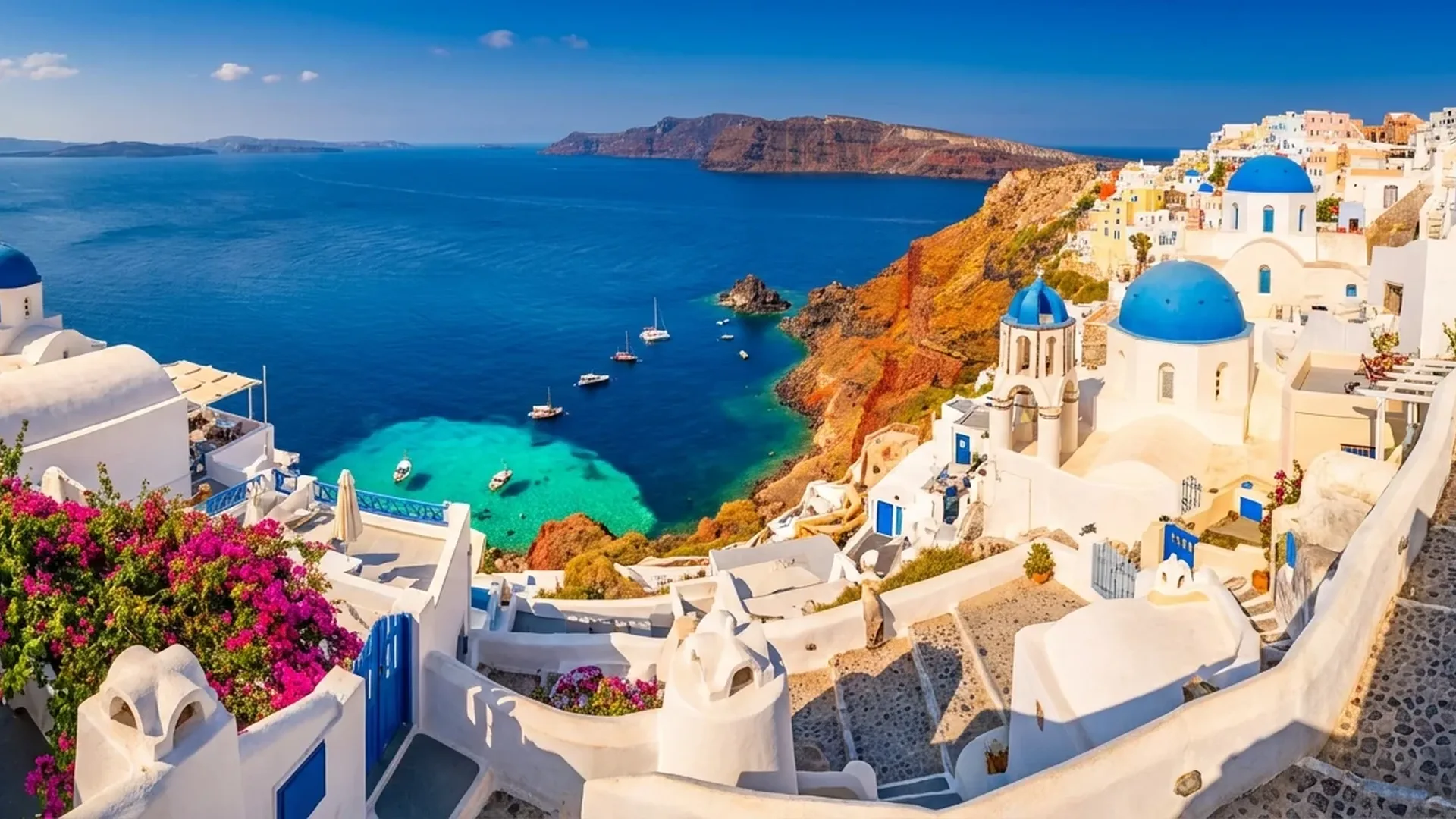
1. Santorini — The Caldera
Santorini is the ultimate drone photography destination in Greece. The volcanic caldera, the cliffside villages, the blue domes of Oia, and the sunsets produce footage that ranks among the best in the world. Best flight time: sunset (Oia) or sunrise (Fira/Imerovigli) for golden light. Fly over the Skaros Rocks in Imerovigli for a view you'll never forget. Note: Santorini is extremely popular — early morning flights avoid the crowds.
2. Milos — Sarakiniko & Kleftiko
Milos hides some of the most surreal landscapes in Greece. Sarakiniko, with its white volcanic rocks resembling a lunar surface, looks stunning from above — ideally in a top-down angle. Kleftiko, accessible only by sea, reveals sea caves with turquoise waters that are impossible to see without a drone. Best season: May-June, before the meltemi winds kick in.
3. Mykonos — Windmills & Little Venice
The iconic windmills of Mykonos, along with Little Venice and the narrow alleys of Chora, create impressive geometric patterns from a drone. Fly during golden hour over the port for cinematic results. Kalafati beach on the southeast side offers calm waters and space without crowds.
4. Naxos — Portara & Interior
The largest island of the Cyclades brings a unique element: mountainous terrain inland with olive groves, Byzantine churches, and stone towers. The Portara — the monumental gate of the Temple of Apollo — guarantees an iconic drone shot, especially in silhouette at sunset. Plaka beach (4 kilometers of uninterrupted white sand) lends itself to linear aerial photographs.
5. Folegandros — Dramatic Cliffs
Small Folegandros, less touristy, offers some of the most dramatic drone shots in the Aegean. The Chora, built on a cliff at 200 meters elevation, the Panagia church at the summit, and the vertical rocks above the sea create images of unmatched drama. Perfect for sunset flights.
6. Koufonisia — Crystal Waters
The small Koufonisia (Pano Koufonisi) is the definition of “crystal-clear water” from a drone. Piscina — a natural pool within the rocks — looks otherworldly in a top-down shot. Italida and Fanos offer equally impressive imagery. Best season: June, before the crowds arrive.
7. Serifos — Hilltop Chora
The Chora of Serifos, built amphitheatrically on a hill above the port, looks like a miniature model from a drone. White houses, windmills, stone alleys — a drone shot from moderate altitude (50-80m) reveals the entire village structure. Psili Ammos and Ganema beaches are ideal for sea-level shots.
Ionian Islands — Green & Blue
The Ionian Islands — Zakynthos, Corfu, Kefalonia, Lefkada, Paxos — stand out with their lush green character, crystal-clear waters, and dramatic coastlines.
8. Zakynthos — Navagio (Shipwreck Beach)
Navagio Beach (Shipwreck Beach) is arguably the most photographed beach in the world — and with a drone, it takes on an entirely new dimension. The white sand, turquoise waters, rusted shipwreck, and 200-meter forked cliffs create a legendary shot. Access is only by sea (boat), so fly your drone from the vessel or from the viewpoints above (Anafonitria/Volimes). Keri Lake in the south offers equally impressive caves.
9. Kefalonia — Myrtos & Melissani
Myrtos is often considered the most beautiful beach in Greece. From a drone, the contrast between the white pebble beach, deep blue sea, and green cliffs is magical. The Melissani Cave, where natural light falls into the lake, creates unique interior footage (if flying is permitted). Fiskardo, with its Venetian houses, is ideal for low-altitude aerial photography.
10. Lefkada — Porto Katsiki
Porto Katsiki on the southwest coast of Lefkada is a beach that takes your breath away. White vertical cliffs framing azure, crystal-clear waters. A drone shot from above, looking straight down (top-down), captures the coastline's geometry perfectly. Egremni, recently restored after the earthquake, is also worth a flight.
11. Corfu — Venetian Heritage
Corfu's Old Town, a UNESCO monument, with the Liston arcade, Spianada square, and the two fortresses, offers architectural aerial photographs of unique beauty. Canal d'Amour in Sidari (sculpted rocks over turquoise waters) produces otherworldly drone shots.
12. Paxos — Sea Caves
Paxos, tiny but enchanting, hides some of the most impressive sea caves in Greece. Tripitos, a natural rock formation with a hole in the middle, reveals itself fully only from a drone. The western coast with its white cliffs resembles a miniature Zakynthos.
Dodecanese & Crete
13. Rhodes — Medieval Town
The medieval town of Rhodes, a UNESCO monument, looks incredible from above — the walls, towers, Palace of the Grand Master. Lindos, with its Acropolis and St. Paul's Bay, offers what is arguably one of the 5 best aerial photographs in the entire Mediterranean.
14. Symi — Neoclassical Colors
Symi's harbor is a photographic masterpiece: colorful neoclassical houses in an amphitheatrical arrangement around a small bay. A drone shot at moderate altitude (40-60m) shows the entire composition. The color contrast (yellow, orange, red houses against blue water) creates exceptional images.
15. Astypalaia — “Butterfly” Island
Astypalaia looks like a butterfly from above — two rocky halves connected by a narrow strip of land. The white Chora with the Venetian castle at the top creates a dramatic image. A drone shot revealing the entire island shape (altitude 100m+) is truly unique.
16. Karpathos — Olympos Village
Olympos in Karpathos, built on a mountain peak, remains one of the most authentic villages in the Aegean. Traditional windmills, colorful houses, rural landscape — drone video here feels like a documentary. Apella, one of the most beautiful beaches in Greece, demands aerial photography.
📖 Read more: Night Drone Photography: Complete Guide
17. Crete — Balos & Elafonisi
Crete, the largest Greek island, offers enormous variety for drone locations. The Balos lagoon on the northwestern tip, with its shallow turquoise waters and white sand, produces exotic shots. Elafonisi, with its pink sand, looks magical in a top-down angle. Samaria Gorge (16 km) offers epic footage if you fly above the “Iron Gates” (the narrowest point at just 3 meters wide). Spinalonga, the historic island fortress, ensures atmospheric aerial photographs.
Sporades & North Aegean
18. Skiathos — 60+ Beaches
Skiathos, with over 60 beaches, is the ideal island for beach drone photography. Lalaria, with its white rocks and natural arch, is accessible only by sea — drone footage here is rare and impressive. Koukounaries, a famous beach set within a pine forest, looks superb in a panoramic shot.
19. Thasos — The Green Paradise
Thasos, in the North Aegean, stands out with dense pine trees reaching down to the sea. “Marble Beach” (Saliara), with white marble pebbles on emerald waters, creates color contrasts that the camera loves. Giola, a natural rock pool, reveals itself fully only in a top-down drone shot.
20. Hydra — No Cars
Hydra, just 2 hours from Piraeus, offers a unique element: no cars, no motorbikes, only stone mansions and donkeys. The amphitheatrical port, with stone buildings in a semicircle, looks like a painting from a drone at 50-80 meters. The absence of vehicles means less noise in your videos.
Drone Flight Regulations in Greece
Flying a drone in Greece is subject to regulations you must know before you fly. Key rules:
- Weight under 249g: Drones like the DJI Mini 4 Pro (~€700 / ~$759) don't require operator registration or exams in most European countries, including Greece (C0 category, Open A1).
- Archaeological sites: Flying over archaeological sites is prohibited without special permission from the Ministry of Culture. This includes Lindos Acropolis, Delos, Knossos, etc.
- Restricted zones: Military installations, airports (8 km radius), border areas.
- Flight altitude: Maximum 120 meters AGL (Above Ground Level).
- Visual line of sight: Always within visual range (VLOS — Visual Line of Sight).
- National Parks: Special regulations in Natura 2000 areas — check locally before flying.
Pro Tip: Use the DJI Fly app as well as AirMap or Avion Map to check flight zones before heading to each location. Many islands have small airports (Santorini, Mykonos, Rhodes) with restriction zones.
Equipment & Settings
For aerial photography across the Greek islands, the ideal settings with the DJI Mini 4 Pro:
- Photography: RAW (DNG) + JPEG, 48MP for landscapes, Panorama Sphere for 360° captures
- Video: 4K/30fps or 4K/60fps HDR in D-Log M for cinematic color grading
- ND Filters: Essential in the Greek summer light — ND16 for morning/afternoon, ND64 for midday, ND256 for bright noon (~€45-60 / ~$49-65 per set)
- Altitude: 30-50m for architectural details, 80-120m for panoramic landscapes
- Golden Hour: 06:00-08:00 and 18:00-20:00 — soft, warm light that highlights the islands
- microSD: 256GB V30 (~€30 / ~$33) — 4K footage fills up fast
"Greece, with over 6,000 islands and islets, constitutes the primary morphological feature of the country and an inseparable part of its culture throughout the centuries." — Visit Greece (Greek National Tourism Organisation)
Challenges & Tips
Flying a drone across the Greek islands presents unique challenges:
- Meltemi: Strong northern winds (July-August), especially in the Cyclades. Fly early morning (before 10:00) or late afternoon. Avoid flights in gusts above 30 km/h — the Mini 4 Pro handles Level 5 (38 km/h) but footage will be shaky.
- Sunlight: The smartphone/controller screen struggles in direct sun. Use a sun hood or the DJI RC 2 with its bright display.
- Salt water: Humidity and salt corrode electronics. Wipe down the drone with a soft cloth after every flight near the sea.
- Batteries in heat: Don't leave batteries in the sun — temperatures above 35°C+ reduce flight time. Store in shade.
- People: Respect locals — don't fly over people's heads, private courtyards, or crowded beaches.
Best Season by Region
Cyclades & Dodecanese
- May-June: Ideal — fewer crowds, calmer winds
- September-October: Warm sea, soft light
- Avoid: August (meltemi winds, peak crowds)
Ionian & Sporades
- May-June: Green landscapes, calm weather
- September: Excellent — warm, calm
- Bonus: Less meltemi, milder winds
Equipment Cost
Complete Setup: DJI Mini 4 Pro Fly More Combo (~€1,010 / ~$1,099) + ND Filters (~€45-60 / ~$49-65) + microSD 256GB (~€30 / ~$33) + Landing Pad (~€15-25 / ~$16-27) = ~€1,100-1,125 (~$1,197-1,224). Under 249g means you fly freely at most locations without paperwork.