For three decades, scientists have been measuring sea level from space. The number they keep returning to is relentless: the oceans are rising, and they're rising faster every year. Now, a team from Hong Kong Polytechnic University (PolyU) has produced the most precise picture yet of how much — and why — using a technique that bounces laser pulses off orbiting satellites.
Their study, published in PNAS (DOI: 10.1073/pnas.2425248122), used Satellite Laser Ranging (SLR) combined with forward modeling to reconstruct global mean sea level change from 1993 to 2022. Lead researcher: Dr. Yufeng Nie (Research Assistant Professor, Department of Land Surveying and Geo-Informatics). Principal Investigator: Prof. Jianli Chen (Chair Professor of Space Geodesy).
📖 Read more: Climate Change Slows Nature Down, Losing Millions of Hours
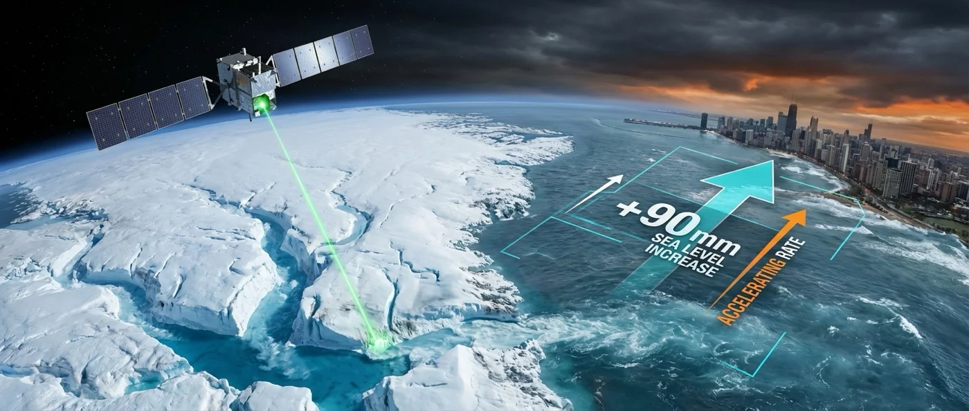
90 Millimetres in 30 Years
The headline result: global mean sea level rose +90 mm between 1993 and 2022 — a 9 centimetre increase over three decades. The average rate of increase was approximately 3.3 mm per year.
But the average masks an acceleration. In the early 1990s, the rate was closer to 2 mm per year. By the early 2020s, it had reached 4–4.5 mm per year — more than double. Each year, the oceans rise a little faster than the year before.
📖 Read more: Methane Surged After 2020: The Cause Is Surprising
What's Driving the Rise?
Sea level rises from two distinct processes: thermal expansion (water expands as it warms) and mass increase (water added from melting ice). The PolyU analysis separated these contributions with unprecedented precision.
Overall, approximately 60% of total sea level rise came from ocean mass increase. Since 2005, when the GRACE gravity satellite constellation launched, mass increase has been the dominant driver. Greenland's ice sheet and mountain glaciers account for more than 80% of that mass increase.
The remaining ~40% comes from thermal expansion — the ocean warming and physically swelling. This component is harder to reverse even if emissions stopped tomorrow, because heat already absorbed by the ocean will continue expanding water for decades.
📖 Read more: Arctic Agriculture: Water Rise Apparently Stores CO2
Why Satellite Laser Ranging?
Most sea level monitoring uses radar altimetry satellites (like Topex/Poseidon, Jason-1/2/3, and Sentinel-6). SLR is different: it fires ultra-short laser pulses from ground stations toward retroreflector-equipped satellites and measures the round-trip time with picosecond precision.
SLR is largely immune to the atmospheric corrections and instrument drift that can affect radar altimetry. By combining SLR data with forward modeling — using physical models of ice, ocean, and land processes to predict expected signals — the PolyU team was able to cross-check and refine the sea level reconstruction beyond what altimetry alone can provide.
Implications for Coastal Planning
A rise of 90mm over 30 years may seem modest, but the consequences for low-lying coasts, river deltas, and small island states are severe. Storm surges that once occurred once per century may now occur once per decade. High-tide flooding is already affecting cities like Miami, Jakarta, and Shanghai on a regular basis.
The acceleration is the most alarming finding. At 4.5 mm per year and increasing, sea level rise is not a distant threat — it is a present and compounding emergency. Infrastructure designed for 20th-century sea levels is already becoming inadequate, and the pace of change is outstripping the timelines of most coastal adaptation planning.